The region where the trail is located is one of the most beautiful sites in Poland, as well as the cradle of the Polish culture. Located among green hills covered with forests with picturesque limestone monadnocks, it offers an impression of unique harmony between man and environment. During the eco-trips, we will learn the history and the legends of castles in Bydlin, Rabsztyn and the Tenczyn Castle in Rudna. We will visit the ‘silver city’ of Olkusz, the birthplace of Polish silver and lead mining dating back to the 13th century. We will discover the natural secrets of the Błędowska Desert (Pustynia Błędowska) – the largest area of shifting sands in the Central Europe, which was formed as a result of forest logging, primarily for the needs of the Olkusz mining industry. We will kayak on the Sztoła River in Bukowno – the emerald river that meanders among precious riparian forests. Eventually, we will drop by Trzebinia to learn the atmosphere of a mining town with an interesting history, where the industrial heritage intertwines with areas of greenery and rural landscape.
SUGGESTED TOURS:
1. Cycling adventures at the Trail of the Eagles’ Nests
Ogrodzieniec-Podzamcze – Smoleń, ruins of the Pilcza Castle – Wodąca Valley – Bydlińskie Mountains – Krzywopłoty – ruins of the castle in Bydlin – Bydlin – Cieślin – Golczowice – Jaroszowiec – Rabsztyn – Olkusz – Racławice (Podskale) – Paczółtowice – Czerna – Krzeszowice – Tenczynek – Rudno, Tenczyn Castle – Kopce, Zwierzyniec Forest – Brzoskwinia – Grzybów, Zabierzów Forest – Szczyglice – Kraków Mydlniki – Kraków Cichy Kącik
Take part in a family cycling trip along the Trail of the Eagles’ Nests’. Our starting point will be at the ruins of the Ogrodzieniec Castle in Podzamcze. To reach this place, we suggest renting a minivan with the capacity to carry bikes. The trip is divided between two days with accommodation in the vicinity of Rabsztyn or Olkusz (tents are recommended). The trail leads along roads through forests and fields and on part of the way on an asphalt road. Differences in elevations within the Jurassic area should be taken into account, along with access roads (usually short) to the interesting sites, as well as sections leading along dirt roads or various types of gravel roads. There are technically difficult sections, e.g., sandy paths in forests, where pushing the bike is necessary from time to time. We know from experience that active children enjoy such adventures and later remember them for a long time. The greatest advantage of the trail is the unique landscape of the Kraków and Częstochowa Jurassic Region, both natural and cultural, and the feeling of closeness with nature.
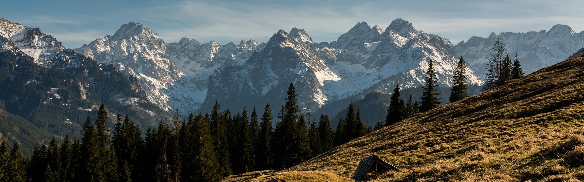
Trail of the Eagles’ Nests
The Trail of the Eagles’ Nests (bicycle and pedestrian) leads along the most beautiful sites of the Kraków and Częstochowa Upland (Wyżyna Krakowsko-Częstochowska). It connects the most noteworthy castles between Kraków and Częstochowa known as the ‘eagles’ nests’.
The idea for the pedestrian Trail of the Eagles’ Nests existed as early as 1948 – one of the initiators was the local expert, Kazimierz Sosnowski. The Trail is 164 km long, with 60 km in Małopolska. It includes: the Korzkiew Castle, the ruins of the royal castle in Ojców, the Pieskowa Skała Castle in Sułoszowa, and the castles in Rabszyn and Bydlin.
From Podzamcze, we set off in the direction of Smoleń to the ruins of the Pilcza Castle from the 14th century, picturesquely set in the Smoleń forest reserve. After a pleasant downhill ride from the castle, we turn to the right (following the red pedestrian trail) to the Wodąca Valley. One of the most demanding sections leading through the forest to the Bydlińskie Mountains (Góry Bydlińskie) is ahead of us. We are cycling mainly along gravel roads in forests, and pass by forest clearings. The Wodąca Valley is one of the most beautiful Jurassic sites and is famous for the complexes of limestone monadnocks and caves. The Zegarowe Rocks tower above the valley. In the Biśnik Cave (Jaskinia na Biśniku), traces of the presence of humans from 500,000 years ago were found. At one of the clearings along the trail, in the place of the former Psarskie forester’s lodge is a gazebo with spaces for resting. Nearby is a monument commemorating ‘Hardy’, a Home Army unit captain who was stationed here in 1944. The highest point on this leg of the trip is 464 m a.s.l.. Later, a steep ride down the hill to the hamlet called Góry Bydlińskie awaits us.
In the neighbourhood of Góry Bydlińskie, we enter the area of Małopolska and head towards Bydlin. Along the way, in the neighbourhood of Krzywopłoty, on Polana Bory, next to the 19th century shrine, is a field altar and next to it is a small monument commemorating a Home Army unit, ‘Surowiec’, that was stationed in the local forests in 1944, as well as plaques for the victims of the January Uprising and the insurrections and wars between 1794 and 1945.
Next, we head to the ruins of the Bydlin Castle. To see the castle, it is best to park the bikes by the carport opposite the old cemetery with graves of soldiers from both world wars, including the graves of soldiers of the Polish Legions. A stone Chapel of the Consolation of the Blessed Virgin Mary from the 18th century, originally a hermitage, attracts attention at the cemetery. The forest on the hill hides ruins of a knightly castle erected at the end of the 14th century that was transformed into a church at the end of the 16th / beginning of the 17th century. There are also remnants of trenches from the First World War. In 1914, units of the Polish Legions fought the Battle of Krzywopłoty here.
Bicycling through Bydlin, we pass by the 1865 Church of St. Margaret (Kościół św. Małgorzaty) with a Renaissance altar, and then go through Cieślin, where a picturesque complex of old court ponds and the Parish Church of St. Stanislaus the Bishop and Martyr (Kościół parafialny św. Stanisława Biskupa i Męczennika) from the 1920s is located at ul. Jurajska. The church houses a Gothic figure of the Blessed Virgin Mary with Baby Jesus from the end of the 14th/ beginning of the 15th century. From Cieślin to Golczowice, we cycle through the forest along a narrow asphalt road with practically no vehicular traffic. In Golczowice, we turn left to ul. Powstania Styczniowego, go across the bridge on the Biała Przemsza River and another interesting leg of the trail awaits us in the forest, first on the asphalt road and then a forest path. We are in the Landscape Park of the Eagles’ Nests. Cycling through a beautiful forest, we reach Jaroszowiec. The town was set up at the turn of the 20th century as an industrial settlement (iron ore mines, a cement plant). However, it grew only in the 1950s, together with the construction of the ‘Szkłobudowa I’ Construction and Assembly Plant and subsequently the Plate Glass Works. The town is surrounded by the monadnocks of the Pazurek Nature Reserve and Mount Stołowa (Stołowa Góra), with beech forests forming a part of the ‘Natura 2000 ˗ Jaroszowiec’ site. We pass by the Church of Our Lady of Succor to the Faithful (Kościół NMP Wspomożenia Wiernych) in Jaroszowiec from 1981––1995, which features the worshipped painting of Our Lady of Succor to the Faithful painted by Jan Szczęsny Stankiewicz, a pupil of Jan Matejko. In front of the church is a statue of St. John Paul II sculpted by Józef Siwoń and dedicated in 2006.
The end of ul. Kolejowa is the end of the asphalt road. We cycle along a path leading through the forest, from time to time passing by clearings full of flowers. This is a particularly charming section of the trail, but also quite demanding on account of the sandy path. Sometimes, pushing the bike is necessary. Yet the reward is not only the proximity of the breathtaking nature, but another eagles’ nest – the Rabsztyn Castle, shrouded in mystery. The ruins of the castle that is dated at late 13th century tower over the limestone elevation. In Rabsztyn, it is worth visiting the hospitable Podzamcze Restaurant. If you planned sleeping in a tent, Rabsztyn is a good place to stop at the bivouac grounds offered by one of the local households. More extensive accommodation is on offer near Olkusz, the cradle of the Polish silver and lead mining known as the ‘silver city’ with origins in the 13th century. Let us definitely stop at the old Market Square and have a look at the sculptures of Olkusz miners.
The trail leads along back roads through Olkusz housing estates. We cross the railway tracks via an overpass and, after going across road No. 791 on another overpass, we again enter rural landscapes. The Powroźnikowa Rock, the largest monadnock in the neighbourhood with a height of 35 m and a great vantage point, is located in Racławice (Podskale). We cycle around its foot, admiring the picturesque view at the rock. We go down to the Racławka Valley, which will lead us to Paczółtowice. We pass by Independence Monument, a rock set on the 100th anniversary of the November Rising of 1830 with an obelisk commemorating the march of an infantry unit under the personal command of Józef Piłsudski on 06.08.1914. The centre of the village features the historical Church of the Birth of the Blessed Virgin Mary (Kościół Narodzenia Najświętszej Marii Panny) of 1510–1515 (tower from the 18th century), which is one of the most valuable monuments of late-Gothic wooden architecture in Małopolska. Constructed with the use of fir wood, it has a log frame structure and a roof covered with shingles. Inside is an early Baroque altar of 1604 with the much-venerated Gothic painting of Our Lady of Paczółtowice from the second half of the 15th century, originally forming the centre of a triptych, with wings placed on the presbytery walls. A Gothic and Renaissance baptismal font from 1533 has also been preserved, along with a Mannerist side altar of St. Nicolaus of ca. 1600 and a late-Gothic painting with the Sorrowful Christ from the beginning of the 16th century.
After riding across Paczółtowice, we head to the gem of nature at the trail – the Eliaszówka Valley Nature Reserve (Rezerwat Przyrody Dolina Eliaszówki) (attention: a sharp turn to the left behind the village). The forest reserve encompasses a valley formed in the Lower Carbon limestone, covered with natural old growth beech, hornbeam oak and riparian forest. The interesting spring of St. Elijah, also known as the Spring of Love (due to the heart-shaped well boarding) is located on the trail. There is also a stone shrine of 1848 here, presenting the Biblical prophet Elijah, who hid in a cave above the Brook Kerith (eastern side of Jordan), drank water from the spring and was fed by a crow. High up, on the right slope of the Eliaszówka Valley is a greatly precious, 17th century Baroque complex of the Monastery of Discalced Carmelites in Czerna (Klasztor oo. Karmelitów Bosych), to which other monuments encountered in the valley are related, such as wayside shrines, Stations of the Cross and walled springs. There is also a Carmelite Museum, a bookshop and a Pilgrims’ House in the monastery.
Discalced Carmelites in Czerna
The heart of the complex of the Monastery of Discalced Carmelites is the church from 1631–1640 with uniform Baroque fittings executed in so-called black marble. We can admire a painting by Tommaso Dolabella of 1640 in the main altar and a worshipped painting of Our Lady of the Scapular from the 18th century in the altar on the side. The Carmelite Museum presents the history of the monastery and tokens from missions to Africa. Ruins of a bridge from the 17th century, commonly known as the ‘Devil’s Bridge’, are located by the Eliaszówka Brook; on the opposite bank, remnants of the former gate have been preserved.
We proceed along the Eliaszówka Valley, pass by the ruins of the old bridge on the Eliaszówka River known as the Devil's Bridge (‘Most Diabelski’) and, further on, the spring of St. Elisha. Next, the Krzeszówka Valley will lead us straight to the centre of Krzeszowice. Cycling along Planty overlooking the Krzeszówka River, we will reach the Krzeszowice park and pass by the neo-Gothic Church of St. Martin (Kościół św. Marcina) one of the leading examples of neo-Gothic architecture in Poland erected between 1832 and 1844 according to the design of Karl Friedrich Schinkel. A bit to the side of the trail is a 19th century palace and park complex of the Potocki family (on the right) and the Krzeszowice Market Square (on the left) with provincial residential development with a row of houses from the 19th and the 20th century.
We go across the Municipal Park, in the past a spa with a ‘shrine’, i.e., a sulphur water intake point, we pass by the old ‘Zofia’ baths, now a balneotherapy centre. We cross the railway tracks via an overpass at ul. Daszyńskiego and then the Krzeszówka River and cycle through the village of Tenczynek. In Tenczynek Rzeczki (corner of ul. Zwierzyniecka and Pareńskiego), reward yourself with a look at the abandoned ‘Eliza’ Villa from the end of the 19th century, which is related to the history of Stanisław Wyspiański’s drama, the ‘Wedding’ (‘Wesele’). The artist often visited the villa, while the daughters of the owner, Professor Stanisław Pareński, are the characters of his drama. The villa was known for meetings of the Kraków art bohemia – the writer Tadeusz Boy-Żeleński also frequented the place and later married Zofia, one of the owner’s daughters. At a distance of approx. 150 m from the villa, the original 19th century entry gate to the former zoo of the Counts Potocki is worth seeing. Along the way to the Tenczyn Castle, we pass by a pond next to the 18th century Baroque Church of St. Catherine (Kościół Św. Katarzyny), with a wooden bell tower from the 18th century.
From here, cycling along ul. Zamkowa, we proceed to Tenczyn Castle. There are picnic facilities and a parking site at the foot of the castle. The 14th century castle was erected by the Kraków province governor Andrzej of the Topór coat of arms (Tęczyński) on the highest elevation of the Tenczyn Hump (401 m a.s.l.). To see the ruins, you must walk with your bike or proceed along the asphalt road following the signs.
After visiting the castle, we turn left from ul. Zamkowa into the forest and cycle for 9 km along a forest road through the Tenczyn Landscape Park and the Zwierzyniec Forest to Brzoskwinia. The Zwierzyniec Forest used to function as a fenced off zoo in the past, set up before 1845 by Counts Potocki, the then heirs of Krzeszowice. It is worth remembering that two hard coal mines operated in the area of the Zwierzyniec Forest: ‘Krystyna I’ (until 1924), next to the present-day diabase quarry called Niedźwiedzia Góra, and ‘Krystyna II’ (until 1955), near Nawojowa Góra. Minor traces still remind us about them, including ruins of a hoist room from the ‘Krystyna I’ mine.
In the vicinity of Kopce, in the place where the trail turns to the so-called Kraków Road (Droga Krakowska) is a forester’s lodge and a forest parking site with refreshment facilities and information boards. Cycling further through the forest, we reach the hamlet of Kamyk and then ride down the hill to Brzoskwinia. In the neighbourhood, the Brzoskwinka Valley (Dolina Brzoskwinki) is worth visiting: it is a small valley in the form of a forested gorge, with limestone rocks strewn across its sides. We will cycle on the picturesque hilltops across Brzoskwinia and Kleczów and enter the Zabierzów Forest (Las Zabierzowski); later, the road leads across fields and meadows with a view to Kraków and goes down to Szczyglice (this section is described in the ‘Family Trips Around Kraków’ eco-trip). The village is located on the eastern edge of the Tenczyn Hump, predominantly in the Rudawa Valley. Its first mention dating to 1374, it remained in the demesne of neighbouring Balice until the end of the 15th century. We cycle through Mydlniki and Bronowice and end our trip at Błonia in Kraków.
Zabierzów Forest (Las Zabierzowski)
It is the largest forest complex in the vicinity of Kraków with approx. 500 hectares of land. It occupies the eastern part of the Tenczyn Hump (Garb Tenczyński), characterised by significant diversity of the lay of land; hilltops elevated at the height of 330–360 m a.s.l. cut across numerous valleys in the form of ravines and gorges with slopes filled with Jurassic rocks. Fertile habitats are a home to numerous species of plants and animals. The wood stand is dominated by beech, oak, larch with hornbeam, pine, spruce and many other species; in the undergrowth there is hazel, alder buckthorn and mountain ash; the ground flora, apart from the omnipresent raspberry and blackberry, also features many species of flowers, including protected ones, such as mezereon, martagon lily, lily of the valley, orchids and violets.
2. Loop on the Trail of the Eagles’ Nests: Rabsztyn – Klucze – Rabsztyn
Rabsztyn Castle – Podgrabie Hamlet – Błędowska Desert, Compass Rose (Róża Wiatrów) – Czubatka (382 m a.s.l.) – Klucze – Jaroszowiec – Rabsztyn Castle
A one-day cycling trip will take us through charming forest wilderness, allowing for close contact with nature and the landscape of the Trail of the Eagles’ Nests. However, a mountain bike will be necessary, as many sections are quite demanding and part of the trail is surfaced with sand. After all, we are cycling in the vicinity of a unique tourist attraction – the Błędowska Desert, the only such formation in Poland.
The trip starts in Rabsztyn, at the parking site near the ruins of the Rabsztyn Castle. For a moment, we follow the road leading to Olsztyn and after a brief moment turn left to a forest road leading to the hamlet of Podgrabie. When the road changes to asphalt, we have reached its end and will turn right, and then take the first turn to the left. We cycle on a path among the fields and reach road No. 791, where we turn right. We continue cycling along the main road for a moment and turn left at the first crossroads. Before we reach the first buildings, we turn right into the forest and follow a forest path at the edge of the Eagles’ Nests Landscape Park (Park Krajobrazowy Orlich Gniazd). Here, let us follow the GPS to turn right in the correct place to the forest road leading to the Błędowska Desert. Through the picturesque forest, we cycle along ul. Bolesławska and go straight to the Compass Rose (Róża Wiatrów) located at the edge of the desert. A large wooden structure with platforms, gazebos, vantage points and educational boards devoted to the Błędowska Desert and the relevant natural, geological and historical titbits was erected here (it is also accessible to persons using wheelchairs).
Now, we will cycle along the edge of the forest and the desert – yet neither the sandy forest tracts nor the necessity of pushing the bike for some time will deter us. The surrounding nature will offer a great reward for our efforts. We cycle to the Czubatka Hill (382 m a.s.l.) – another vantage point in the Błędowska Desert. It is rather hard to get to the top of the hill on bikes, so a short steep climb awaits us. The vantage point offers a marvellous view of the ‘Polish Sahara’. From Czubatka, we go down to Klucze along ul. Górna. Along the way, let’s drop by a souvenir and tourist shop and purchase some local handicrafts (e.g., miniature oil paintings with floral motifs by the painter Urszula Lemańska, from Klucze). On the roundabout in the centre of Klucze, we turn to ul. Rabsztyńska and then ul. Kolejowa and go to Jaroszowiec, where the next signposts for the Trail of the Eagles’ Nests are visible. We make our way right to the Rabsztyn Castle through the picturesque forest along a sandy forest path. Now is the time to see the ruins, which are undergoing reconstruction. The castle is extremely photogenic from various perspectives!
3. Kayaking in the Sztoła River in Bukowno
‘Leśny Dwór’ Reservoir – Manor House at ul. Borowska (end haven)
We cover quite a short (3 km) section in the kayak, yet the character of the river keeps us busy along the route. Its strong current, natural obstacles and numerous meanders make the trip an exciting challenge. Kayaks may be rented in Bukowno at the starting point at ul. Spacerowa where the Baba River meets the Sztoła River. The Sztoła flows through a picturesque valley, deeply cutting into the sandy bed. It has a unique, emerald colour. The river banks are overgrown with reeds and valuable riparian forest full of black alder, European ash, rowan and goat willow; grey alder was also spotted there. There are multiple protected plant species in the forests surrounding the river, which also the habitat of moose.
4. Cycling Around Trzebinia
Trzebinia (railway station) – Chechło Reservoir – Piła Kościelecka – Bolęcin, Triassic Rock – Dulowska Forest – Droga Alwerska – Dulowa – Psary – Płoki-Kościół – Czyżówka – Trzebinia-Siersza – Trzebinia-Wodna – Trzebinia ‘Balaton’ – Trzebinia railway station
The red trail is a proposal that allows for seeing the beautiful natural and historical assets of the Trzebinia area. The trip can be divided into two shorter legs, the northern and the southern loop, and we encourage you to explore all of it.
From the railway station in Trzebinia, we first go south to Lake Chechelskie (Jezioro Chechelskie). Along the way, we pass by the Sanctuary of Our Lady of Fatima (Sanktuarium Matki Bożej Fatimskiej). The neo-Gothic Church of the Blessed Heart of Jesus (Kościół Najświętszego Serca Pana Jezusa) is the home for the miraculous figure of Our Lady of Fatima. The Salvatorians brought it here from Fatima in 1962. The interior of the church stands out with its beautiful stained glass windows and a 35-pipe organ.
Lake Chechelskie, also known as the Chechło Reservoir, is an artificial dam reservoir supplied by the Chechło River and Młoszówka Brook, which flow from the Dulowska Forest. A beach has been organised by the lake and several recreational centres operate here. Around the lake, in the reeds, mud plants can be found such as glyceria maxima, bulrush and narrowleaf cattail, reeds and rush, as well as quite rare simplestem bur-reed. Orchids and other interesting species of blossoming plants grow on the marshy meadows nearby, e.g., Turkish marsh gladiolus, marsh gentian and Siberian iris and autumn crocus, both of which are protected species.
Now, we will take the back roads and go to Piła Kościelecka and further to Bolęcin. Here, the greatest attraction is the picturesque Triassic Rock (Skałka Triasowa) – a limestone monadnock and a unique feature of nature. In Bolęcin, the Thematic Village Under the Rock (Tematyczna Wioska pod Skałą) was set up, which references the legend about mysterious dungeons located under the rock, connecting it with Tenczynek Castle. The village is described in the ‘Charming Jurassic Landscape Discovered from a Handcar’ Eco-Trip (www.facebook.com/wioskapodskala). From Bolęcin, we go towards the Dulowska Forest (Puszcza Dulowska) and, after crossing the A4 highway, enter the fairy-tale forest complex located within the perimeter of the Tenczyn Landscape Park (Tenczyński Park Krajobrazowy). It is a remnant of the ancient forest that spreads from Kraków up to the Przemsza Valley. This natural site is a habitat for beavers and ungulate mammals – even moose!
We follow Droga na Siejkę and then turn left, to the north, to Droga Alwerska, which leads us through the Forest to Dulowa, a village where two landscape parks converge – the Kraków Valleys Landscape Park (Dolinki Podkrakowskie) and the Tenczyn Landscape Park (Tenczyński). A thematic village was set up here: Dulowa – the Lost Village (Zaginiona Wioska). According to the authors of the initiative:
The name makes reference a pair of the Formoza heirs, known as Froszka and Marcin, also known as Satan, and to the mysterious disappearance of the Łaziska village, which existed in this area centuries ago. The Lost Village of Dulowa is a place where you can discover a bygone world of symbols, places, professions, flavours and traditions.
From Dulowa, through meadows and forests, we reach Psary. The trail leads next to the early 20th century neo-Gothic Chapel of the Holy Cross (Kaplica św. Krzyża) that was re-modelled in a ‘highlander’ style. Inside is a wooden crucifix from the 16th century. In a moment, we will ride along a forest road on the edge of the Kraków Valleys Landscape Park to Płoki. We turn left by the Church of Our Lady Patron of Working Families (Kościół Matki Bożej Patronki Rodzin Robotnicznych) in Płoki, The white church with a slender tower erected in the 1950s on the Zagajnik hill is a site of Marian worship. It guards the miraculous painting of Virgin Mary with Baby Jesus from the second half of the 15th century.
Along ul. Dworska, we cycle towards the forest and proceed to the village of Czyżówka towards the Siersza Power Plant holiday resort. Going along, we cycle through forest and industrial areas in the direction of Trzebinia’s ‘Balaton’. The ‘Balaton’ bathing site is located in an unused pit, while the trail leads along the upper edge of the former limestone quarry. A popular resort with a beach was set up here; there are also restaurants, an adventure park, a zip line and even a climbing wall. Finally, a short trip to the centre, to the Trzebinia Market Square, is a good idea. Here, you can follow the Trzebinia Trail of Jewish Culture and the Holocaust (Trzebiński Szlak Kultury Żydowskiej i Holocaustu), which features, among others, the Jewish cemetery, the Zieleniewski manor house with a display devoted to the history of the Trzebinia Jews and other important memorial sites.
MOST IMPORTANT SITES ON THE TRAILS
Olkusz – The Silver Town
Olkusz, next to Bochnia and Wieliczka, belongs to the oldest mining centres in Poland. The first references to the lead ores (with an admixture of silver) mined here date to the mid-13th century. It was probably at that time that the original settlement known as the Old Olkusz (Stary Olkusz) was transferred and the town was set up in the present-day location before 1299. The development of the mining industry, fostered by numerous royal privileges, determined the significance of Olkusz which, among others in the 15th century, became one of the main suppliers of lead in Europe, experiencing its ‘golden age’ from the beginning of the 16th century. A royal mint operated here between 1578 and 1601. However, the depletion of the deposits, damage from mining activity and natural disasters in the second half of the 17th century, all aggravated by the war with the Swedes, led to a gradual downfall of the town. Olkusz experienced a renewal only at the beginning of the 19th century along with the construction of the zinc ore mines. In the 20th century, significant changes came in the 1960s and the 1970s, when new mines were opened; in recent times, given the depletion of the ore, the mines are slowly winding down their operations.
The picturesque Market Square is lined with historical townhouses. The ‘Gmerki’, i.e., old burgher coats of arms, have been preserved on some of them. A multimedia tourist route is available in the cellars of the Gothic town hall. We can learn more about the history of Olkusz, the Olkusz mining industry and heritage of the region in the PTTK Regional Museum of Antoni Minkiewicz, located at the Market Square in a historical townhouse from the 16th century. It is one of the oldest regional museums in Poland set up in 1911 by Antoni Minkiewicz (1881–1920). Minkiewicz was a mining engineer and a social activist as well as a supply minister.
A true gem of sacral architecture is the Basilica of St. Andrew (Bazylika św. Andrzeja) from the end of the 13th/ beginning of the 14th century with opulent interior design and fittings. Here, we can see the famous Olkusz polyptych of 1485 (with characteristic late-Gothic altar retable), the Renaissance main altar, the Gothic pews and the pipe organ from the first half of the 17th century, one of the oldest instruments of this type in Europe.
The visit at the Olkusz Market Square is made easy by the Silver Trail of Olkusz Miners (Srebrny Szlak Gwarków Olkuskich). The circular educational and historical path, marked with figurines of miners, is also equipped with a multi-media application. Over 130 replicas of old coins have been placed in the pavement along the route of the trail.
Olkusz is also called the town of museums: you can visit the Museum of Władysław Wołkowski (a well-known Polish designer who specialises in wicker products), the Museum of Fire-Fighting in the Olkusz Land, the Collection of Minerals and Fossils and the African Museum.
Bukowno: Mining and Metallurgical Traditions Surrounded by Opulent Nature
Bukowno is located at the border of the Silesia Upland (Wyżyna Śląska) and the Kraków and Częstochowa Upland (Wyżyna Krakowsko-Częstochowska) by the Biała Przemsza, Sztoła, Baba and Warwas Rivers and surrounded by pine, mixed and beech forests. This region has been an important economic area for centuries. The former village of Starczynów (today a part of Bukowno) was purchased in 1402 by the council of the royal town of Olkusz from Knight Rafał from Michów. In the mid-16th century, Starczynów was a well-developed mining and industrial settlement, and a paper mill operated here for nearly 80 years starting in the late 16th century. Paper with a watermark featuring the Olkusz crest deriving from here was distributed throughout the contemporary Republic of Poland and was used for the publication of the act of the Lublin Union of 1569. On the other hand, Old Bukowno (Stare Bukowno) belonged to the Kraków bishops and the so-called Sławków demesne from the 15th century to the end of the 18th century. In 1789, the Sławków demesne became the property of the State Treasury. In this period, a manor house with a farm and steelworks existed in the area of Bukowno. A zinc and lead mining centre was developing rapidly here from the beginning of the 19th century; calamine mines also operated here, among them ‘Ulisses’ in Tłukienka and ‘Jerzy’ in Starczynów; in 1885, construction of a railway track was launched. However, the greatest industrial boom related to mining and zinc and lead metallurgy took place in the 1950s when the ‘Bolesław’ mine was operating. In 1962, Bukowno received municipal rights.
The history of industry and mining and metallurgical traditions are presented in the exhibition in the Mine of Knowledge (Kopalnia Wiedzy o Cynku) arranged in the premises of the historical administrative building of the former ‘Ulisses’ mine.
Bukowno: The Natural Gem
Bukowno, in spite of the industrial development, has not forfeited its natural and recreational assets. Especially valuable elements of the landscape are the Sztoła Valley: greatly picturesque, forested, and meandering, as well as the inselberg hills towering over the area: Diabla Góra (382.9 m a.s.l.) and neighbouring Stoskowa Góra (362.5 m a.s.l.), covered with forests of valuable Sącz beech and thermophilic orchid beech. The thermophilic beech forest is particularly valuable on account of the richness of the undergrowth, as well as its relic-like character. It is a southern-European complex, in Poland present in clusters, in various sub-types, among others in the Pieniny Mountains, in the Sudety and in the Kraków and Częstochowa Upland (Małopolska sub-type). Among protected plants, special attention should be paid to orchids, martagon lily, columbine, white adder's mouth and Daphne mezereum, lily of the valley, asarabacca and alder buckthorn, which are also present in the Sztoła Valley.
Trzebinia: Mining Vibes and Manor Houses
The name of the town comes from the Polish word ‘trzebić’, meaning to log a forest. Trzebinia was a well-known mining centre where coal, zinc and lead ores were exploited. The town has a rich history dating to the 12th century. Already in 1415, as royal property, it received mining rights and rights under the Magdeburg law. For centuries, the town belonged to several owners: it was in the hands of the Trzebiński family for the longest period, from the mid-16th century to the beginning of the 19th century. The first owner from this family was Jerzy Schilhra vel Silha, who adopted the name Trzebiński. This was the heyday and the period of growth of the town, which had the privilege of organising fairs and the Jewish community had the right to trade. The town received municipal rights in 1817 from the Senate of the Free City of Kraków. In the first half of the 19th century, five mines, two zinc factories and a glass works were operating here. New operations were set up later, among others a calamine/ zinc ore mine, and at the beginning of the 20th century, heavy industry with a refinery, a power plant and a cement plant were operating there. At that time, the Salvatorians arrived in the town and started to build a church designed in the neo-Gothic style by a well-known architect and art conservator, Jan Sas-Zubrzycki, nowadays the Sanctuary of Our Lady of Fatima (Sanktuarium Matki Bożej Fatimskiej).
During WWII, Trzebinia was incorporated into the Third Reich. Forced labour and prison camps as well as a sub-camp of Auschwitz-Birkenau were set up here. The fate of the Jews of Trzebinia is described in exhibits at the Trzebinia Trail of Jewish Culture and the Holocaust.
The history of the development of industry in the town is recounted by the Regional Museum in the former mining baths in the premises of the retired ‘Zyszek’ shaft.
One of the major historical venues in the city is the Zieleniewski manor house, surrounded with a park, with history dating back to the 13th century. The present-day building has an 18th century character with a distinctive Polish mansard roof. It bears the name of the last owners of the manor house and the coal mine: Paulina and Zbigniew Zieleniewski (currently, a cultural centre and a hotel with a restaurant operate here).
OTHER INTERESTING SITES
Wolbrom
Located on a limestone foreland at the height of 375-385 m a.s.l., it is the area for the headwaters of the Biała Przemsza River, which begins in the Wolbrom peatlands. The history of the former royal town dates back to the beginnings of the 14th century. Wolbrom was set up by brothers Wolfram and Hilary, the Kraków burghers, whom King Ladislaus the Short (Władysław Łokietek) gave the right to log the forest. It was a merchant and handicraft town, but in contrast to other towns, its functions went far beyond the local market. These functions were determined by the town's location at the crossing of important trade routes, connecting Małopolska, Wielkopolska and Śląsk. The privilege given by King Ladislaus the Short in 1400 exempted the town from customs and fair fees in the Kraków lands and ordered the merchants travelling along the trails connecting Kraków and Wielkopolska to go through Wolbrom, according to the information presented on the official website of the commune. The city’s downfall started in the 16th century with a change of the trade route; in the next century, great destruction was wreaked during the Swedish deluge. Its revitalisation started in 1931 when Wolbrom received town rights once again. During WWII, 8,000 Jews lived in the town’s ghetto; the majority of them were taken to the extermination camp in Belzec by the Nazis. Only 300 Jews from Wolbrom survived the war... They are commemorated in the 19th century building of the former Jewish school and a fragment of an old cemetery.
Development in the oldest part of the town has retained its small-town character with two-storey townhouses from the end of the 19th century at the Market Square and the characteristic houses with hallways with two doors on the opposite ends of the building. The most valuable sacral monument is the Baroque Church of the Immaculate Conception of the Blessed Virgin Mary (Kościół Niepokalanego Poczęcia Najświętszej Marii Panny) made of larch wood in 1638. It functioned as a church next to a hospital. Its beautiful façade with a triangular gable is very characteristic. The interior is filled with Baroque paintings.
It is worth visiting the Wolbrom fair (open on Wednesdays in the afternoon and on Thursdays until noon) which has been held continuously since the 15th century. A variety of delicious local products can be purchased here.
Chrzanów
Chrzanów is a town located by the Chechło River that still has its old Medieval chessboard layout with the Market Square and streets arranged perpendicularly. The Chrzanów castellany was set up in the 13th century, when the name of the town started to appear in various documents. Chrzanów received municipal rights in the 14th century; the local privilege was granted by King Casimir the Great (Kazimierz Wielki). Until WWII it was a private town held by various families. Between the 14th and the 17th century, Chrzanów was in the hands of the Ligęza family of the Półkozic coat of arms. This was a period of its rapid growth; Chrzanów remained open, there were no defence walls, and it received permits for fairs. A customs chamber and a weaving guild were set up; lead ores became the object of lucrative trade, and increasing numbers of Jewish people started flowing into the town. The decline of Chrzanów coincided with the Swedish attacks. Dynamic new industrial development took place in the inter-war period, when the first Polish Locomotive Factory, Fablok, was set up here. The outbreak of WWII was tragic for the town and its residents; the Jewish community was exterminated (at that time, the Jewish community numbered approx. 8,000 people, almost a half of the town’s residents).
The Chrzanów Market Square is decorated by a complex of 19th century townhouses, that are entered in the register of monuments. The fin de siècle two-storey townhouse with No. 13 stands out. Its façade made of glazed brick and decorations in the shape of chestnut tree leaves attract attention. It is worth taking a stroll in the Municipal Park and listening to the songs of blackbirds, tits, finches and buntings; even the green woodpecker lives here. The green area is a remnant of the former manor house park with multiple specimens of old trees. Two hundred species of plants were recorded here: trees, bushes and flowers. From the side of ul. Mickiewicza, a former farmhouse from the 16th century has been preserved in the park that today houses the Chrzanów Museum of Irena and Mieczysław Mazaraki, where we can learn about the history of the town and the region, including its rich cultural heritage. One of the most valuable collections is the Judaica related to the religious worship of the Jews of Chrzanów. Two nature and didactic paths start at the Museum in Chrzanów: the wetland meadows in Kąty; the forests in the Chrzanów Basin; the ponds in Groble and the Chechło River Valley along with Mount Żalatowa and, last but not least, Pogorzyce.
MAJOR LOCAL EVENTS
- The Feast of Silver and Handicraft and Local Produce Fair
- Dulowa Picnic, Dulowa – Zaginiona Wioska
- Defence of the Tenczyn Castle During the Siege by the Swedes
- Night with Ghosts
- The Zieleniewski Tea Party, i.e. A Retro-Style Picnic, Park at the Zdrojewski Manor House
- Family Bike Rally
- Family Rallies on Olkusz Bike Trails
- Juromania Festival
YOU MUST TRY THESE
- Caban-style potatoes: featured on the list of traditional products; the recipe is handed down from generation to generation. The Caban community were shepherds who settled in the Chrzanów lands during the times of the Tatar attacks in the 13th century. The dish was traditionally prepared in the fields and pastures, on open fire in a clay pot, sometimes a cast-iron cauldron, especially during the harvesting of root crops. Its vegetarian version can also be prepared by replacing meat with mushrooms or beans;
- The Jura lamb from Olkusz and cooked Jura lard entered in the list of traditional products (promoted by the Local Action Group [Lokalna Grupa Działania] ‘Nad Białą Przemszą’);
- Honey from Jura, among others from apiaries Jurajska Pszczoła from Bukowno (nomadic apiary, Wodąca 32) and Pasieka Miodowy Ogród in Olkusz.
- ‘Czar Pustyni’: moonshine produced from rye growing in the vicinity of Błędowska Desert and spring water. The beverage is listed as a traditional product. The rye is put into vats and water and sugar or local honey is poured over it.
- Beer from the Tenczynek Brewery.