Route 1 – The Dunajec Valley, that is, on the trail of a volcano and organs played by the wind
Region: Podhale , Gorce , Pieniny, Beskid Sądecki
Route: Nowy Targ – Łopuszna – Harklowa – Dębno Podhalańskie – Kluszkowce – Krościenko nad Dunajcem – Zabrzeż – to Kraków through Kamieniec and Mszana Dolna – to Nowy Sącz through Łącko
Distance: 49km (to Zabrzeż)
Road Markings: DW 969, DW 968
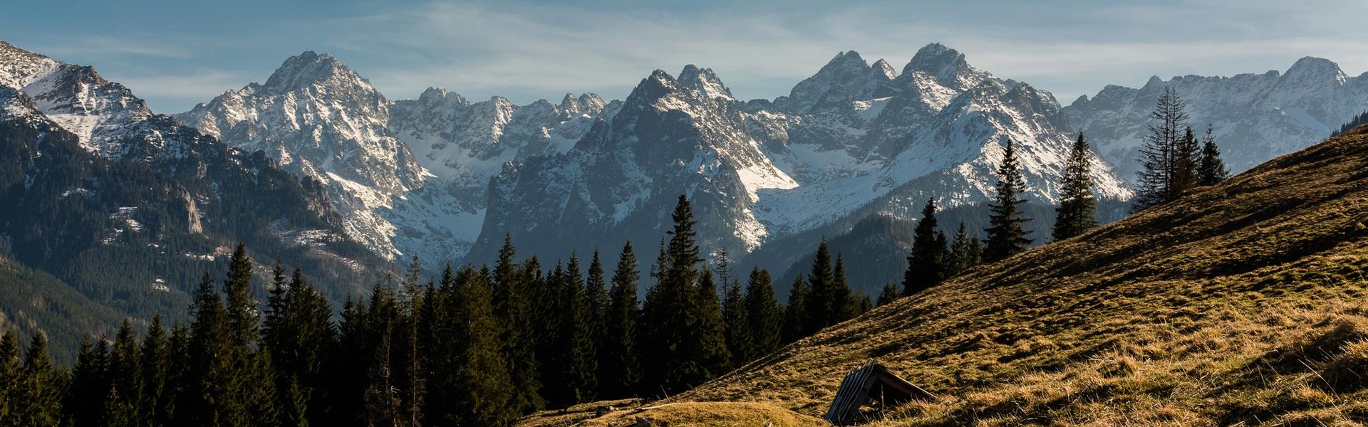
One of the most beautiful roads in Poland due to its variability, location and views. In good weather, while driving along the Dunajec and the Jezioro Czorsztyńskie (Czorsztyn Lake), you can see a beautiful panorama of the Tatra Mountains , Pieniny and Beskid Sądecki. There are many places to stops, sightsee or to relax. Just past Nowy Targ , in Łopuszna (description of Łopuszna) there is a 15th century church and the Tetmajer family manor (where Kazimierz Przerwa-Tetmajer, one of the most outstanding representatives of Young Poland was born) and a cultural centre dedicated to the philosopher, rev. Józef Tischner (this is where he came from and the cemetery where he is laid to rest is). Next, there is Dębno Podhalańskie with one of the most beautiful wooden Gothic churches in the world – Szlak Architektury Drewnianej (Wooden Architecture Trail). The road now winds between the descending slopes of the Lubania Range and the banks of the Jezioro Czorsztyńskie (from under the bridge over the Dunajec you can see two rivers flowing into the lake – Białka and Dunajec). A few kilometers after the bridge, the village of Maniowy, which is visible on the left hand side, begins. It was built entirely in the 1980s. The old village of Maniowy was flooded and remains at the bottom of Jezioro Czorsztyńskie and is known only from the preserved photographs. The Czorsztyn Reservoir, also known as the Lake, was planned in the interwar period due to repeated catastrophic floods in the lower part of the Dunajec. After many years of construction, it was opened in July 1997 and stopped the gigantic flood wave from rising in the upper part of the Białka and Dunajec rivers. Let us remind you that Poland was then hit with the so-called the flood of the millennium. The height of the water is evidenced by the fact that the water overflowed on the day of the official opening through the drain in the crown of the dam. The reservoir is 9 kilometers long, 1.3 kilometers wide and has almost 30 kilometers of coastline. With the average state of the rivers, it is about 19 meters deep and can hold up to 230 million cubic meters of water.
Next, there is Kluszkowce (in the winter a ski station – the lift operates also in the off-season), in the summer the roller coaster from Góra Wdżar (a former volcano – an interesting place). The mountain (767 m above sea level) being the keystone between the Gorce Mountains and Pieniny is one of the most versatile tourist destinations. There is also a ropes course, Bike Park, downhill bike trails, a nature trail, a place for rock climbers, and even a bar at the top with stunning views. You can spend the whole day here. Parking is under the lower station of the ski lifts or on the Snozka Pass.
You must make a stop at the Snozka Pass (635 m above sea level – convenient parking), from which there is a unique view of the Tatra Mountains and Pieniny (and further the Beskid Sądecki ), the Jezioro Czorsztyńskie and the whole Kotlina Nowotarska. There is a unique monument – “Organ” by Władysław Hasior, which was created in the Polish People's Republic in honor of the so-called fixators of the people's power. The intention has passed, and the monument has survived thanks to its originality. In the wind, the monument supposedly sounds like an organ, and there are even people who have heard it.
We then go down to Krościenko nad Dunajcem , which is partially a spa town, full of small guesthouses, with a church from the second half of the 15th century . The main trails of the Pieniny begin here – to Trzy Korony (Three Crowns) and the Snozka Pass, and the main red trail to Turbacz through the Lubania range. The Dunajec appears again in Krościenko, which was hidden earlier behind the peaks of the Pieniny Mountains . It is worth paying attention to the bridges that cross the river here. This is the only road connecting nearby Szczawnica with the rest of Poland. The bridges look the same, but one of them dates back to 1934. We drive beside the river to the south and southeast along a charming, wide promenade route somewhat reminiscent of Italian roads, with the slopes of the Beskid Sądecki on the right hand. In the town of Zabrzeż, we have to make a choice – go back to Kraków or turn to Nowy Sącz. It is worth taking this route in the late afternoon, when the sun is already in the west. Visibility is much better then, and the sun illuminates the peaks of the Tatra Mountains.
Route 2 – to the Przełęcz Knurowska. Military secrets of the empire, i.e. the most winding road in Małopolska (variant of the first route)
Region: Gorce
Route: Harklowa – Knurów – Przełęcz Knurowska – Ochotnica Górna – Ochotnica Dolna – Rzeka (Tylmowa)
Distance: approx. 26 km
Road Markings: local roads
This road is a real monument. Not only a monument, but also a military secret. We do not realise how large of investments the Austro-Hungarian Empire made here during World War I. One of them is the road from Harklowa (late Gothic wooden church from the end of the 15th century ) through the Przełęcz Knurowska to Ochotnica Dolna, which met the strategic requirements as a backup route in case the Nowy Targ – Krościenko road was cut off. Its parameters were unprecedented elsewhere: sharp turns, but small hills for a route with a height difference of over 300 m! All this so that the horses could pull out heavy cannons, and the enemy's artillery could not shoot at the convoy going down the road. For the latter reason, it was also planted with ash trees, whose foliage formed a dome like structure over the road, keeping it from the sight of airplanes. Here, you can see the almost unheard of passes (small strips of shoulders on the side of the road) needed to pass large-size military transports. It is a completely unexpected memento of the great war. There are also original culverts from 100 years ago on the route.
What was necessary for the military is a great obstacle for the contemporaries. Narrow, probably the most winding road in Małopolska, has no communication significance, but it is a great tourist stop. Starting the route in Harklowa and passing Knurów, we climb like a plane to an altitude of 834 m above sea level, with the Kotlina Nowotarska, Pieniny and Tatras in the rearview mirror. Limited views from the pass itself, but it is enough to walk a bit along the red trail to the east to find one of the most beautiful views of Podhale and the Tatra Mountains. The pass separates Gorce from one of its ranges – Pasmo Lubania. We go down a less winding road to two charming towns deep in the Gorce valley, in which the Ochotnica stream flows – Ochotnica Górna and Dolna. Górna is a popular summer destination, but without the crowds of fast food, and experts say it is also the center of the Wallachian culture in Podhale. We leave the valley in the hamlet Rzeka, at the mouth of the Ochotnica stream to the Dunajec river .
Route 3 – to Trzy Korony (Three Crowns) (variant of the first route). Who wanted to flood the priceless church, Inca treasures and the most beautiful view in Małopolska
Region: Pieniny
Route: Dębno Podhalańskie – Frydman – Niedzica – Sromowce Wyżne – Sromowce Niżne – Sromowce Wyżne – Czorsztyn – Kluszkowce – Dębno Podhalańskie
Distance: approx. 51 km
Road Markings: local roads
Only slightly over 50km long, with enough sightseeing to last three days. Dębno Podhalańskie, the already known Gothic, wooden church , may not have existed. If we look at this part of the Jezioro Czorsztyńskie (Czorsztyn Lake) , we can notice that the village Dębno, along with its Church, it lies on a strange headland, below the mirror of the reservoir. Dębno Podhalańskie, just like Maniowy, was supposed to disappear under water. The priceless church was also supposed to be flooded. According to the local tale, the American Polish diaspora, outraged by this, started collecting money to dismantle the church and transport it to the USA. Therefore, the Polish authorities decided to separate the area of Dębno from the planned reservoir and surround it with high embankments.
Next, we go south-east, we pass the extremely interesting village of Frydman with an early Gothic church with beautiful wall paintings, an octagonal chapel and an original tower, as well as an early Renaissance castle , i.e. a defensive manor. Beyond Frydman, the road rises and suddenly lifts us about 200 meters above the lake level. It may bring some discomfort to those less adventurous, so it is worth keeping it in mind. The next few kilometers make us feel like we are flying instead of driving. The road lifts us up, only to lower us to the level of the lake again. Here, the entire Pasmo Lubania (Lubiana range) is laid before us. We pass Falsztyn, where you can go down to the bay next to one of the most valuable reserves in this part of the country. The “Zielone skałki” (Green rocks) are 100 meter cliffs that descend into the lake’s waters and are part of the Pieniny National Park. We then arrive in Niedzica – the centre of this region. Here is the Medieval Dunajec castle (it is one of the castles where, as legend has it, the legendary treasure of the Incas is to be located) and the dam holding the lake’s waters with a hydroelectric power plant. The castle, with the crown of the dam, is one of the most attractive places in Małopolska, and the view from the dam on the Jezioro Czorsztyńskie , the Nidzica Castle and the Wronin Castle , laying on the bank of the Jezioro Czorsztyńskie, is one of the symbols of this region. In Niedzica, there is also a beach by the lake, water equipment rental, as well as a sailing marina, from where you can sail to the other shore to Czorsztyn or across the lake. The problem, especially in the high season, is the small number of parking spaces.
We go down to Sromowce Wyżne, passing the small Sromowicki Reservoir, to the former level of the Dunajec and only from there, looking back, you can see the power of the dam. Right in front of the bridge on the Dunajec, there is Polana Sosny , one of the most interesting recreational places, part of the VeloDunajec bicycle path junction. We climb up the foot of the hill to turn from the main road into a wide clearing to Sromowce Niżne, to the point where all roads end. We come to another section of winding road that requires our attention, then find ourselves at the bottom of the Dunajec valley quite quickly, going to the only place from which you can see the several hundred meters high cliffs of Trzy Korony. On the way, we pass the starting pier of the Dunajec rafting, and after a few kilometers, we reach the village. You can then go on foot across the footbridge on the Dunajec river to Czerwony Klasztor (Red Monastery) on the Slovak side of the river, or to the Trzy Korony mountain hut . All of this is within a few hundred metres of each other.
We return along the same route to the main road, drive up a winding road again, this time among forests and on the ridge of the northern slopes of the Pieniny Mountains, and next go down to Czorsztyn where we can find equally picturesque castle ruins . Both castles used to be part of the defense of the borders of the Kingdom of Poland (Czorsztyn) and Hungary (Niedzica). The Czorsztyn castle, although in worse condition, is more famous. Polish and Hungarian kings used to visit it and important historical events took place. In addition, the building is slowly lifting itself from the ruins. Czorsztyn itself is a holiday resort, full of boarding houses and other accommodation places. From Krościenko, a narrow local road, from which even more magnificent views of the lake, and with a bit of luck also the Tatra Mountains , we descend to Kluszkowce and return to Dębno through Maniowy.
Route 4 – to the heart of the Tatras. Travelling in the mountains 100 years ago and where the light of Bethlehem comes from
Region: Tatra Mountains, Podhale
Route: Zakopane – Poronin – Małe Ciche – Bukowina Tatrzańska – Głodówka – Droga Oswalda Balzera (Zazadnia-Brzeziny – Cyrhla) Zakopane
Distance: approx. 50 km
Road Markings: 961, 960
Let's try to go back in time and imagine how tourists used to go to Morskie Oko over a century ago, around 1900. They travelled in horse-drawn carts called a fasiąg. It is a wooden wagon finished in wicker. In case of bad weather, the fasiąg was covered with a tarpaulin. The trip took about 5-6 hours one way. We are taking the same route.
Driving north from Zakopane and reaching Poronin, we turn towards Bukowina Tatrzańska. The road slowly climbs to soon reveal the peaks of the Tatra Mountains before us. The highest hill awaits us in front of Bukovina itself. Let's imagine a fasiąg, which, laden with tourists, was pulling them up the mountain to their first rest stop. Today, Bukowina Tatrzańska, the highest Polish municipality, is one of the most prestigious resort towns with hotels, guesthouses and the first complex of thermal pools in Podhale .
However, we have to climb higher, to Wysoki Wierch, to be at the culmination of the local hills. After a few kilometers, we start winding through a forest that restricts our view. But after a short while, we enter the great Polana Głodówka, from where one of the most beautiful Tatra panoramas spreads out, including almost the entire range. On the left, we can see the protruding peaks of Murania and the Belianskie Tatras, in front of us there are the High Tatras with the Lodowy and Jaworowy peaks, the dominating Szeroka Jaworzyńska, Wysoka and Rysy, the wall of the Mięguszowieckie peaks, Wołoszyn, Świnica, Giewont, all the way up to Kominiarski Wierch. It's good to take a short break here in the scout shelter built in the early 1930s. The shelter is extremely friendly with a warm atmosphere. This is from where the so-called light of Bethlehem is distributed throughout Poland in the Christmas season.
We set off towards the Tatra Mountains , Łysa Polana and the road to Morskie Oko. During the high season, traffic can be very heavy, so it is best to go on a trip this way in the late spring or late autumn. At the roundabout in Wierch Poroniec, we turn to Łysa Polana, going downhill with sharp turns, and we can look deep into the Belianskie Tatras with Murań and Hawrań at the fore. This road is named after Oswald Balzer, which will be discussed in a moment. Łysa Polana is a former border crossing (only the buildings are left). The bridge in Białka would lead us to Slovakia, but our route will lead us straight to Morskie Oko. Our journey ends after a few kilometers in the large Polana Białczańska, where there is a large parking lot (online booking only). Now, it is time for a relaxing walk. The carts that take tourists to Morskie Oko today are modeled on the original fasiąg. In the 1980s, PKS buses traveled to Polana Włosienica, quite close to the lake. Before the war, it was possible to travel to the shelter itself. Because of the winding, steep roads, car races were organised here many times.
We return to the roundabout on Wierch Poroniec and head left towards Zakopane. This is the main part of the Oswald Balzer's road, built in 1902 under the pressure of growing tourist traffic, and in the 1950s its surface was made of gravel. It used to be a scenic route where successive fragments of the Tatra Mountains were shown one after another. In the last 20 years, the growing forest has blocked almost all views and today it is rather an access road to the beautiful Tatra valleys and glades – Rusinowa Polana with the nearby Sanctuary of Our Lady in Wiktorówki (it is best to leave the car at Wierch Poroniec), Polana Zgorzelisko with the former secret complex holiday resort for dignitaries of the communist party, and today an atmospheric hotel with a fantastic view (entrance allowed), the Polana Filipka, Zazadnia, or Brzezin – from here you can take the easiest family route to Polana Gąsienicowa and the Murowaniec shelter.
Right behind Brzeziny, from Cyrhla, we have a beautiful view of Zakopane and the western part of the Tatra Mountains. And so we return to Zakopane, reminding ourselves who Oswald Balzer was and why he has a road named after him here. He was a legal historian born in an Austrian family who became a Pole. It was he who headed the Polish delegation to the famous arbitration court in Graz, which in 1902, finally awarded the area of the Morskie Oko to Galicia, not Hungary. This meant that the lake belonged to Poland. On the news of this, patriotic demonstrations took place in many Polish cities.
Route 5 – Dolina Poprad. Rocky cliffs, wide promenades, forest tunnels and vast river valleys
Region: Beskid Sądecki
Route: Nowy Sącz – Stary Sącz – Rytro – Piwniczna-Zdrój – Żegiestów-Zdrój – Mszana – Krynica-Zdrój – Nowy Sącz
Distance: approx. 98km
Road markings: DK 87, DW 971, DK 75
It is one of the greatest attractions of Beskid Sądecki , though almost never advertised. The road from Nowy Sącz to Krynica-Zdrój , is winding, narrow in places, arduous, but unrivalled in terms of views. It is only 66 km long, but the attractions it offers are enough for a motorised tourist for the whole day. Let's start with the fact that first, it leads along the Poprad river , a river that is not as picturesque as the Dunajec, but just as interesting, because, first of all, it also flows from the Tatra Mountains, but from the opposite side of the Główny Grzbiet (Main Ridge), - secondly, its turn also separates the Beskid Sądecki into the Radziejowa and Jaworzyna ranges. Another unusual and interesting phenomenon of the river is in Żegiestów-Zdrój , where it has a turn of 180 degrees and creates a peninsula that now houses the health resort district of Łopata Polska. Starting from Stary Sącz, the road leads, among others, through Rytro (ruins of the medieval castle ), Piwniczną-Zdrój (excellent healing waters, charming Galician market square), Żegiestów-Zdrój (pearls of modernist architecture), Milik (a former Lemko village with a wooden church from the beginning of the 19th century), Muszyna (an aspiring health resort with mineral water pump rooms, sanatoriums, and a modern active recreation park), and Powroźnik (orthodox church entered on the UNESCO World Heritage List ). However, the views from the route, especially in autumn, are delightful – there are rocky cliffs, wide promenades, forest tunnels and vast river valleys. For the sake of order, we add that Poprad also has its own rafting trip. We can stop anywhere on this route and stay longer.
An obligatory stop is of course Krynica-Zdrój, one of the most splendid Polish resorts, competing with Zakopane for a long time. In addition to the healing waters, the attraction of the place is its charming pubs, good restaurants and some very interesting excursion offers, from a walk to Parkowa Mountain (there is also a funicular railway there, and an age-old cable car to Kasprowy Wierch) to a gondola ride to Jaworzyna Krynicka.
When you leave Krynica, you have to go to Krzyżówka and join DW 75 here, still leading down to Nowy Sącz. We are on the northern side of the Beskid Sądecki, less visited but just as interesting. We can find several interesting nature reserves here (Uhryń, Łabowiec and Borowiec). You must stop in Łabowa (a beautiful brick church from the 18th century, stray a few kilometres to the famous beekeeping centre in Kamianna and visit the Studnicki palace in Nawojowa. At the end, of course, a walk around Nowy Sącz is the cherry on top.
We also recommend:
The road along the Beskids
Region: Beskid Wyspowy, Beskid Makowski, Beskid Żywiecki, Beskid Mały
Route: Mszana Dolna – Rabka-Zdrój – Jordanów – Maków Podhalański – Sucha Beskidzka – Zembrzyce – Mucharz – Gorzeń Górny – Wadowice
Distance: approx. 71 km
Road markings: DK 28
The road through Pogórze Ciężkowickie
Region: Tarnów and the surrounding area
Route: Bochnia – Nowy Wiśnicz – Żegocina – Limanowa – Łososina Górna – Nowe Rybie – Łapanów – Chrostowa – Bochnia. Warning: a very complicated route
Distance: approx. 86 km
Road markings: DW 965, local roads
The road through the Beskid Wyspowy
Region: Beskid Wyspowy
Route: Limanowa – Stara Wieś – Przełęcz pod Ostrą – Zalesie – Kamienica – Lubomierz – Łętowe – Wilczyce – Jurków – Chyszówki – Słopnice – Limanowa
Distance: approx. 74 km
Road markings: DW 968 and local roads
Ojcowski route
Region: Jura Krakowsko-Częstochowska
Route: Sułoszowa – Pieskowa Skała – Ojców – Prądnik Korzkiewski – Wielka Wiś – Ujzad – Rudawa – Szklary – Jerzmanowice – Przeginia – Paczółtowice – Czatkowice – Paczółtowice – Sieniczno
Distance: 97 km
Road markings: local roads